MAKE A MEME
View Large Image

| View Original: | 1867_Stiles_Map_of_Brooklyn,_New_York_-_Geographicus_-_BrooklynTwn-stiles-1867.jpg (4000x2704) | |||
| Download: | Original | Medium | Small | Thumb |
| Courtesy of: | commons.wikimedia.org | More Like This | ||
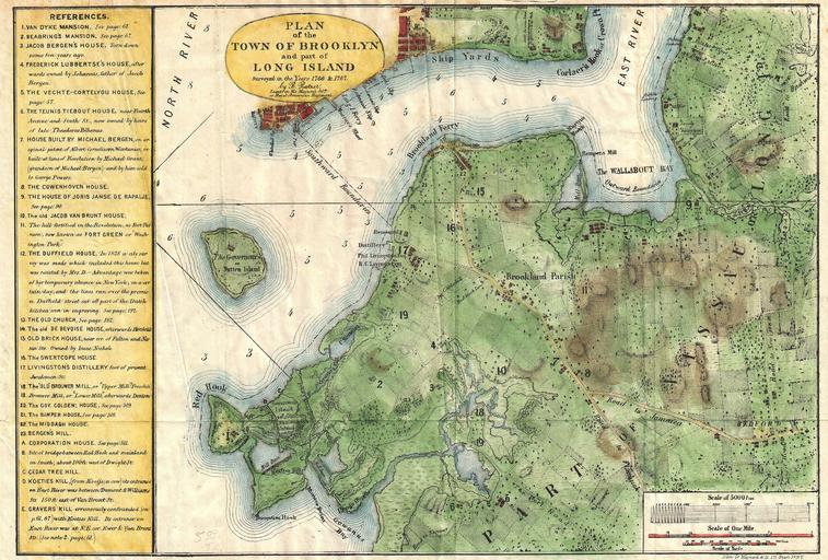
| Keywords: 1867 Stiles Map of Brooklyn, New York - Geographicus - BrooklynTwn-stiles-1867.jpg A rare and very attractive plan of Brooklyn New York drawn in 1867 by Samuel Edward Stiles Designed for Stiles ™ important History of Brooklyn this map is based upon surveys of Brooklyn originally taken in 1766 and 1767 by w Bernard Ratzer en Includes much of modern Brooklyn including parts of Red Hook Gowannas Fort Greene Williamsburg part of Greenpoint Brooklyn Heights Cobble Hill Carrol Gardens Park Slope Prospect Height Clinton Hill and Greenwood Offers superb detail to the level of individual buildings many of which are numbered and labeled in the interesting chart to the left of the map proper Interestingly this chart notes both 18th century building locations as well as their 1867 street locations “ many of which are consistent to modern times Includes the Van Dyke Mansion the Seabrings Mansion the Jacob Bergen House the Frederick Lubbertse House the Vechte-Cortelyou House the Teunis Tiebout House the Michael Bergen House the Cowenhoven House the Jorse Janse de Rapalje House the Jacob Ban Brunt House the Duffield House the OldChurch the De Bevoise House the Old Brick House the Swertcope House the Livingston Distillery the Old Brouwer Mill Brouwer Mill the Governor ™s Colden House the Bamper House the Middagh House Bergan ™s Hill a Coporration House Cedar Tree Hill Koeties Kill and Gravers Kill Drawn by Edward Stiles and engraved by Hayward and Company of 171 Pearl Street New York 1867 undated Size in 15 5 11 object history credit line accession number BrooklynTwn-stiles-1867 Stiles S E <i>History of the City of Brooklyn Vol 1</i> page 62 Geographicus-source PD-art Old maps of Brooklyn New York City 1867 maps Brooklyn Cobble Hill Brooklyn | ||||