MAKE A MEME
View Large Image

| View Original: | Computer_animation_showing_May_18,_1980_St_Helens_landslide.png (788x812) | |||
| Download: | Original | Medium | Small | Thumb |
| Courtesy of: | commons.wikimedia.org | More Like This | ||
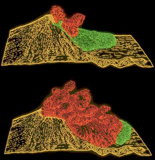
| Keywords: Computer animation showing May 18, 1980 St Helens landslide.png These illustrations show the landslide green and directed blast red that occurred during the first few minutes of the eruption of Mount St Helens in 1980 Before the eruption an estimated 0 11 km³ of dacite magma had intruded into the volcano equivalent to sphere about 600 m in diameter The rising magma forced the volcano's north flank right side of illustration outward about 150 m and heated the volcano's ground water system causing many steam-driven explosions phreatic eruptions Following a magnitude five earthquake on the morning of May 18 1980 a landslide green unroofed the hot magma and surrounding hydrothermal system and the resulting rapid depressurization caused a series of steam and volcanic gas driven explosions The explosions burst through part of the landslide blasting rock debris northward The resulting pyroclastic surge quickly overran the landslide and spread over ridges and valleys across an area of 550 km² USGS image by T R Alpha and text from http //volcanoes usgs gov/Imgs/Gif/Drawings/30210600-084_caption html Computer animation showing May 18 1980 Mount St Helens landslide USGS image by T R Alpha 1980-05 U S government PD PD-USGov 1980 eruption of Mount St Helens Lateral blasts 1980-05-18 Pyroclastic flows Dacite Diagrams of volcanic eruptions Landslide diagrams Volcanism of Mount St Helens Lava dome eruptions Diagrams of Mount St Helens | ||||