MAKE A MEME
View Large Image

| View Original: | San Jose-San Francisco-Oakland CSA.svg (620x733) | |||
| Download: | Original | Medium | Small | Thumb |
| Courtesy of: | commons.wikimedia.org | More Like This | ||
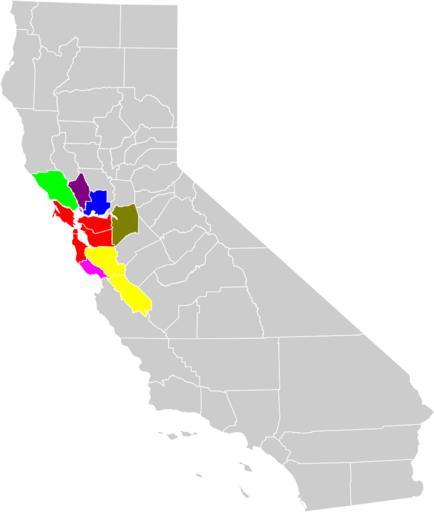
| Keywords: San Jose-San Francisco-Oakland CSA.svg Locator map of the w San Francisco Bay Area San Jose-San Francisco-Oakland Combined Statistical Area in the western part of the U S state of California The six components of the CSA are colored separately Red Red - San Francisco-Oakland-Fremont Metropolitan Statistical Area Yellow Yellow - San Jose-Sunnyvale-Santa Clara Metropolitan Statistical Area Green Green - Santa Rosa-Petaluma Metropolitan Statistical Area Blue Blue - Vallejo-Fairfield Metropolitan Statistical Area Magenta Magenta - Santa Cruz-Watsonville Metropolitan Statistical Area Purple Purple - Napa Metropolitan Statistical Area Olive Olive - Stockton-Lodi Metropolitan Statistical Area Based on File San Jose-San Francisco-Oakland CSA png Reverified from https //ask census gov/cgi-bin/askcensus cfg/php/enduser/std_adp php p_faqid 779 p_created 1103300340 p_sid j5zGsZyj p_accessibility p_lva p_sp cF9zcmNoPSZwX3NvcnRfYnk9JnBfZ3JpZHNvcnQ9JnBfcm93X2NudD0mcF9wcm9kcz0mcF9jYXRzPSZwX3B2PSZwX2N2PSZwX3BhZ2U9MQ p_li p_topview 1 US Census http //www census gov/geo/www/maps/msa_maps2003/msa2003_previews_htm/cbsa_us_wall_0603_rev htm http //www census gov/geo/www/maps/msa_maps2003/msa2003_previews_htm/cbsa_csa_us_wall_0603_rev htm http //www whitehouse gov/sites/default/files/omb/bulletins/2013/b13-01 pdf Added Stockton-Lodi CA Metropolitan Statistical Area comprising San Joaquin County see p 109 Original was Modified from http //www2 census gov/geo/maps/general_ref/cousub_outline/cen2k_pgsz/ca_cosub pdf this United States Census Bureau file based on the following Census definitions lists http //www census gov/population/www/estimates/metro_general/2006/List4 txt Metropolitan Statistical Areas http //www census gov/population/www/estimates/metro_general/2006/List6 txt Combined Statistical Areas 2009-05-28 User Optigan13 File San Jose-San Francisco-Oakland CSA png validSVG Maps of the San Francisco Bay Area Maps of Alameda County California Maps of Contra Costa County California Maps of Marin County California Maps of Napa County California Maps of San Benito County California Maps of San Joaquin County California Maps of San Mateo County California Maps of Santa Clara County California Maps of Santa Cruz County California Maps of Solano County California Maps of Sonoma County California Maps of census statistical areas in California | ||||