MAKE A MEME
View Large Image
| View Original: | TitanicRoute (ru).svg (800x332) | |||
| Download: | Original | Medium | Small | Thumb |
| Courtesy of: | commons.wikimedia.org | More Like This | ||
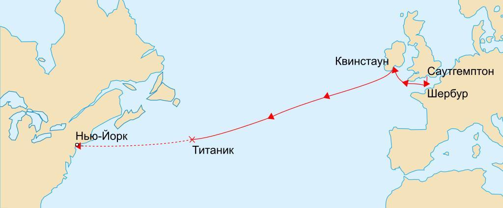
| Keywords: TitanicRoute (ru).svg лџл░Л Лѓл░ л╝л░Л ЛѕЛ ЛЃЛѓл░ л┐лхЛ л▓лЙл│лЙ лИ лхл┤лИлйЛЂЛѓл▓лхлйлйлЙл│лЙ л┐л╗л░л▓л░лйлИЛЈ л┐л░Л лЙЛЁлЙл┤л░ лблИЛѓл░лйлИл║ лъЛѓл╝лхЛЄлхлйЛІ л┐лЙЛ ЛѓЛІ лйл░ л╝л░Л ЛѕЛ ЛЃЛѓлх л░ Лѓл░л║лХлх л╝лхЛЂЛѓлЙ лил░ЛѓлЙл┐л╗лхлйлИЛЈ Map marks the route of RMS Titanic during her maiden voyage the ports on that route and approximate location of where she sank on 1912-04-15 The remaining portion of her uncompleted route is shown dashed Version vectorielle de Image TitanicRoute png RMS Titanicin neitsytmatkan reitti Yhten├цinen viiva kuvaa toteutunutta reitti├ц 10 Њ15 huhtikuuta 1912 Uppoamispaikka on merkitty rastilla ja suunniteltu loppumatka katkoviivalla TitanicRoute svg 2010-12-10 08 07 UTC TitanicRoute svg Image originale en User Gary Joseph en User MechBrowman ; image vectorielle Rogilbert derivative work Vasyatka1 <span class signature-talk >talk</span> Simply translated into russian Vasyatka1 TitanicRoute svg Titanic ship 1912 maps Maiden voyages | ||||
.svg)